Getting through King's Lynn isn't all that difficult but
then someone said. "What about a route in pictures". So
here it is.
Note that some detais may have changed such as the old Sugar
Beet factory now replaced by a paper mill.
Notes. In the text 'North' means going in the
direction of Sandringham and obviously 'South' is, well,
the other way. Statements such as this is the best route
etc. are the opinion of the author and not necessarily that
of KLWNBUG. The route shown is the authors usual way
through and based on, and mostly follows, the Sustrans
Route 1 I'm not absolutely sure that cycling in The Walks
is 100% legal but I've never heard of anyone having a
problem. The Walks park is also to be developed in the near
future so this route may be disrupted by reconstruction
work and who knows what cycling there will be like.
Interested parties may like to follow this link The Walks Restoration
Project
Traveling South towards King's Lynn Route 1 takes us
through Castle Rising. here is the turning (right) from the
Castle Rising road towards North Wootton.
Locate using Streemap
Follow this turning past The 'House On The Green' pub and
into North Wootton village. Stay on the main road past a
general store on the right and look out for the Millennium
Pyramid under the trees on the right, that's where the
cycle path goes off.
Follow the path left (heading South) over the small
bridge.
Continue on the path until reaching the exit onto the road,
right to the junction and left on the road. Some may wish
to use the cycle path on the pavement opposite the
junction.
Take the next right after the house.
Locate using Streemap
Now you get a choice. You can follow the cycle path round
the back of the church which is narrow and not in the
authors opinion best suited to trikes, or you can go on
past the church on the road.
The cycle path exits back on to the road on the right. Note
that the view shown below is heading North. The cycle path
entry/exit is on the right just after the lamp post.
The turning from the Northern bypass as seen when heading
North
and the same turning showing the cycle path when heading
South into King's Lynn, definitely best to use this section
of path.
Locate using Streemap
Heading South cross the road at the crossing point here and
continue in the same direction for a short distance,
before turning left (South) onto the cycle path which
follows the route of the old Hunstanton railway line. The
line was another casualty of the Beeching cuts and ran
through several villages including Wolferton (which was the
royal stop for Sandringham) on its' way to Hunstanton.
Locate using Streemap
The view looking North onto the Northern bypass, turning
right here when heading for Sandringham.
Picture shows the Millennium signpost opposite the local
sports centre where locals can be observed driving onto the
car park to get some exercise at the sports facilities.
Beware of the illegal motorised users especially the two
wheeled ones.
Picture shows the front of the sports centre looking from
the Millennium signpost
Carry on along the path until you reach the Gaywood Road
crossing and the same crossing heading North. The cycle
path continues on the other side of the road.
Locate using Streemap
Heading South shows the turning right towards the level
crossing where this route crosses the road and heads into
town and the railway station.
Heading South the route crosses the level crossing and the
road to continue through The Walks (public park). The path
through The Walks can be seen under the trees just after
the railings. Take care crossing here.
Locate using Streemap
The level crossing as seen heading North from the Walks
path exit.
Heading into King's Lynn here the path exits onto the road
at the traffic lights. Continue (if heading South) with the
swimming pool on your left and take the next left, or
straight on to go into the town centre and Post Office. Oh
yes at this point you have passed the turning to the
railway station. Cycle parking for bikes is available in
several locations, one used to be opposite the Post Office,
we await the replacement (10/02/06)
Going South, then continue, for those going North then go
to the next picture. Just after passing the swimming pool
turn left to be faced with King's Lynn's newest
'improvement' a car park. The road you want is on the
opposite side of this fine new structure. Go around the car
park by turning left, or as shown here, right. Picture
shows the view looking back from the car park.
(construction now finished).
Picture shows the road you are heading for after
circumnavigating the car park, the police station is on
your left down the road above. On leaving the road past the
police station turn right (take care on exit).
Now you should have a small park on your left, take the
next left to the traffic lights where you should turn
right, or dismount and walk through the pedestrian section
and on into the town centre.
After turning right at the lights this is the view to your
rear. If going North then the turning on the left is a no
entry, one way to get to the cycle path through The Walks
is to go straight down this road (The Millfleet) turning
left at London Road (T junction and traffic lights), and
then right onto the cycle path at the traffic lights beside
the swimming pool, or cross the main road and go through
The Walks. Note - do not turn right on the road as it is a
No Entry. Access to the cycle path is from the pedestrian
crossing at the swimming pool lights.
If going South then continue along here taking the first
exit at the paint blob (sorry roundabout), for access to
the town centre go to your right at the roundabout, or
straight over to get access to the quay, visit The Green
Quay for tea and cake. The
Y.H.A. is also down this way.
The view seen heading South from the paint blob, and next
approaching the paint blob when heading North.
Picture shows the next turning heading South. Go just past
the red car and to the right of the 'temporary' fence, then
past the Old Town Wall Gateway. Next the view traveling
North.
Views of the Old Gateway
The next turning southbound is the start of the riverbank
cycle path, go to the right here.
Follow the path up and along the riverbank, the river will
be on your right if heading South.
Continue along the river bank until you reach the road
crossing (old A17) with the bridge to your right. Take care
here getting past the anti-motorbike barriers. The old hoops have been
replaced by a more cyclist friendly system.
Locate using Streemap
The North bound riders view approaching the road crossing
(old A17).
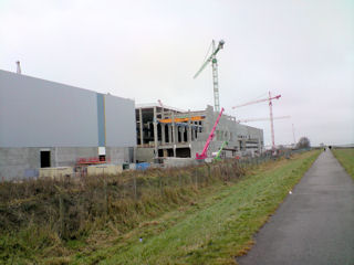
The ex British Sugar Factory site and original office block
which was on your left if heading South,has been demolished and replaced
by a paper mill, seen here under construction.
At the end of this section of path turn to the left.
and follow the path.
until you reach the gate, oh bother that finger's there
again.
The entry to the path as seen by the North going traveler.
The road goes round to the right, we go to the left for
King's Lynn.
Locate using Streemap
King's Lynn Power Station, taken from the cycle path.
The view in the Saddlebow direction from the South end of
the path. all by Neil
That's it folks

.jpg)
.jpg)
.jpg)
.jpg)
.jpg)
.jpg)
.jpg)
.jpg)
.jpg)
.jpg)
.jpg)
.jpg)
.jpg)
.jpg)
.jpg)
.jpg)
.jpg)
.jpg)
.jpg)
.jpg)
.jpg)
.jpg)
.jpg)
.jpg)
.jpg)
.jpg)
.jpg)
.jpg)
.jpg)
.jpg)
.jpg)
.jpg)
.jpg)
.jpg)
.jpg)
.jpg)
.jpg)
.jpg)
.jpg)
.jpg)
.jpg)
.jpg)
.jpg)
.jpg)
.jpg)
.jpg)